
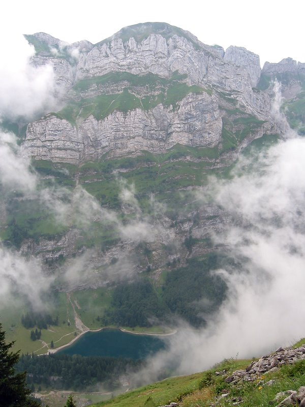
Saturday, December 30, 2006
La Grande Combe de Lioux, Provence, France
Starting in La Combe bei Lioux, Provence, walking up the hill, through shrubs and wild herbs towards the farm "Bezaure", made a side-trip to the ruins of "Le Castellas", great views, then down into the canyon "La Grande Combe de Lioux", back through the green bottom of the canyon to La Combe (ca 4h, some ups and downs, easy but rocky).
Monday, December 25, 2006
Christmas Day Hike: Colorado Provencal
Hike near Rustrel, Provence, France.
Starting at the Camping du Colorado, along the Sentier du Blaces to Croix de Christol, back along the Sentier Morenas(ca 12 km, 3h).
Nice, easy hike in the provencal country side, through lavender fields, vineyards, forest, nice views, towards end some great ocre cliffs.
Starting at the Camping du Colorado, along the Sentier du Blaces to Croix de Christol, back along the Sentier Morenas(ca 12 km, 3h).
Nice, easy hike in the provencal country side, through lavender fields, vineyards, forest, nice views, towards end some great ocre cliffs.

Sunday, December 17, 2006
Allschwil -> Neuweilerstr.
This was a random short walk for a sunny Sunday afternoon.
We started from the tram stop in Allschwil, continued to Schoenenbuch, crossed the Geiser to Ziegelhof, then passed the Herzogenmatt to end up at the Neuweilerstrasse tram station.
Nothing particularly fancy here, just a stroll through some fields. Still, very nice.
We started from the tram stop in Allschwil, continued to Schoenenbuch, crossed the Geiser to Ziegelhof, then passed the Herzogenmatt to end up at the Neuweilerstrasse tram station.
Nothing particularly fancy here, just a stroll through some fields. Still, very nice.
Sunday, November 05, 2006
Frick -> Mumpf
This walk, from Frick->Schupfart->Obermumpf->Mumpf was an adaptation of an U-abo hike that would have had us end in Stein. After getting to the Mumpf Flühe panorama viewpoint, we opted to continue to Mumpf rather than heading back a bit and going to Stein.
Total length was just under 4 hours, about 12 km, with about 300m vertical.
Total length was just under 4 hours, about 12 km, with about 300m vertical.

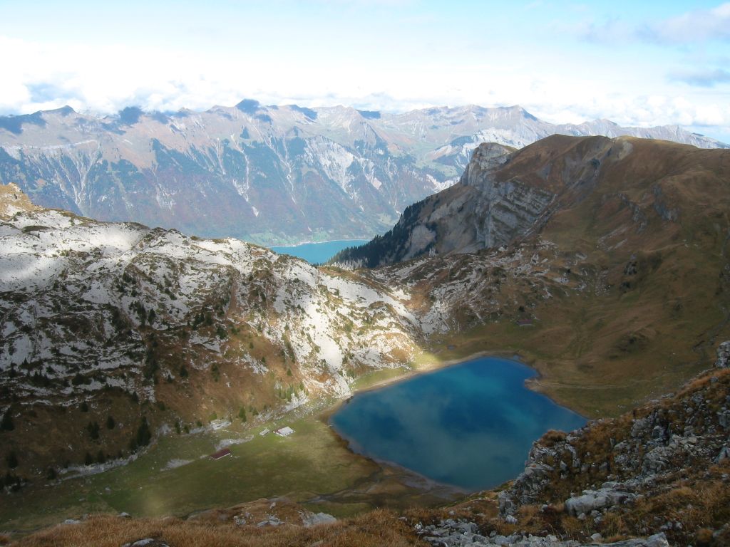
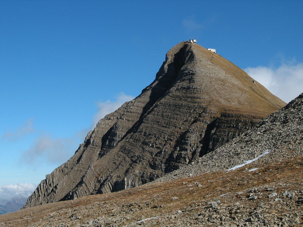
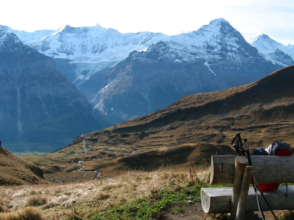
Sunday, October 22, 2006
Schynige Platte -> Faulhorn -> Grosse Scheidegg
We did this walk in two days, spending the night at the Faulhorn.
Day 1:
Von Wilderswil (584 m) with the cog railway up to Schynige Platte (1967 m). On the Panorama Weg via Oberhornberg (2069 m) and Egg (2125 m) to Mändlenen (2344 m) and on to the Faulhorn (2680 ), stay overnight at Faulhorn Hotel (~ 4 “Alp-Hours”, 5 ½ “greg-and-andrea-hours”)
Day 2:
From Faulhorn (2680 m) via Bachsee (2265 m) to First (2167 m), then to Grosse Scheidegg (1962 m), by bus down to Grindelwald (1034 m). That was an easy, lazy Sunday stroll on a wheelchair-accessible autobahn, but very scenic.
Andrea and I on the ridge just past the Shynige Platte station, Brienzersee in background:

Sägistalsee, Brienzersee in background:

The Faulhorn, with the amazingly exposed Berghotel:

A view across to the Eiger (center-right), and Jungfrau (far right):

Day 1:
Von Wilderswil (584 m) with the cog railway up to Schynige Platte (1967 m). On the Panorama Weg via Oberhornberg (2069 m) and Egg (2125 m) to Mändlenen (2344 m) and on to the Faulhorn (2680 ), stay overnight at Faulhorn Hotel (~ 4 “Alp-Hours”, 5 ½ “greg-and-andrea-hours”)
Day 2:
From Faulhorn (2680 m) via Bachsee (2265 m) to First (2167 m), then to Grosse Scheidegg (1962 m), by bus down to Grindelwald (1034 m). That was an easy, lazy Sunday stroll on a wheelchair-accessible autobahn, but very scenic.
Andrea and I on the ridge just past the Shynige Platte station, Brienzersee in background:

Sägistalsee, Brienzersee in background:
The Faulhorn, with the amazingly exposed Berghotel:
A view across to the Eiger (center-right), and Jungfrau (far right):
Sunday, September 03, 2006
Basel -> Riehen
This spontaneous Sunday walk, from our flat to the Wiese and then along the Wiese to Riehen, was pretty short (less than 1.5 hours), but noteworthy because of how convenient it was and because we should remember how easy it is to get to a green walk along a little river.
Also noteworthy, particularly since our bikes and blades get here this week, is that we saw signs for a nice looking rollerblading loop (8.8km) that runs along this stretch.
Also noteworthy, particularly since our bikes and blades get here this week, is that we saw signs for a nice looking rollerblading loop (8.8km) that runs along this stretch.
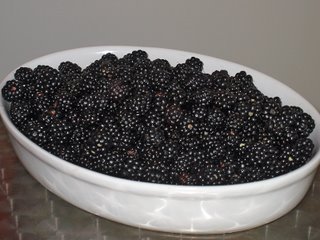
Sunday, August 20, 2006
Aesch -> Flüh
This was a "make our own fun" tour where we picked a start-point on a tram line (Aesch) and then an end point on a tram line (Ettingen), picked a route that looked interesting on our map, and then set out, making adjustments along the way of course.
The route we ended up taking was:
Aesch -> Unter Chlus -> along the ridge of the Blauberg -> Bergmatten -> Hofstetten -> Flüh
I don't have much of a feeling for the total distance, but we walked for between five and six hours (including lunch).
We didn't do the world's best job of making the trip efficiently, which is why we went back via Flüh instead of Ettingen, but some of that had to do with the disappointing quality of the signage in the area. It wasn't anything like up to the standards we've seen on our other walks. Luckily it's almost impossible to get lost around here because there are walking paths EVERYWHERE.
There were no really impressive photo opportunities, so no landscape/ruins photos, but we did find tons of blackberries. If we had had sufficient carrying capacity with us, we probably could have brought back kilos of berries. This is all that fit in our emptied nalgene bottle + the tupperware bowl I brought quick-pickles in for lunch:

Tuesday, August 01, 2006
Alpstein Trip Day 4: Hundsteinhütte -> Brülisau
Low clouds and lots of rain... We took the quick way out. Hundsteinhütte (1554 m) -> Brülisau (922 m), about 8.5 km of easy downhill along a "road".

Monday, July 31, 2006
Alpstein Trip Day 3: Seealpsee -> Hundsteinhütte
This was a relatively short day from Seealpsee (1144 m) -> Meglisalp (1517 m) -> Widderalpsattel (1856 m) -> Widderalp (1644 m) -> Chalberweid (1340 m) -> Hundsteinhütte (1554 m). Total distance was about 8.5 km.

Sunday, July 30, 2006
Alpstein Trip Day 2: Schaefler Hutte to Seealpsee
Day 2 was a long one with lots of up and down:
Schäfler -> Säntis -> Lisengrat -> Rotsteinpass -> Meglisalp -> Seealpsee
The morning was the Schäfler (1923 m) -> Säntis (2503 m) leg (~6km). In the afternoon we did the second bit along Lisengrad to Rotstein pass (1620 m), Meglisap (1517 m), and finally Seealpsee (1144 m). Total distance there is a bit tricky to figure out, but it's about 7 km.
Schäfler -> Säntis -> Lisengrat -> Rotsteinpass -> Meglisalp -> Seealpsee
The morning was the Schäfler (1923 m) -> Säntis (2503 m) leg (~6km).
 In the afternoon we did the second bit along Lisengrad to Rotstein pass (1620 m), Meglisap (1517 m), and finally Seealpsee (1144 m). Total distance there is a bit tricky to figure out, but it's about 7 km.
Saturday, July 29, 2006
Alpstein Trip Day 1: Wasserauen -> Schaefler Hutte
Due to rain, we took the gondola from Wasserauen (868 m.ü.M.) to Ebenalp (1644 m.ü.M.) and then walked from there to Schäfler (1924 m.ü.M) by way of Aescher. Total distance was about 4 km with about 400m of climb.
Photo through the clouds from our lunch spot, looking across the valley towards the Gloggereren (~1630 m.ü.M) and Marwees (2056 m.ü.M). The Seealpsee (1141 m.ü.M), our destination for day two is at the bottom of the picture.

Photo through the clouds from our lunch spot, looking across the valley towards the Gloggereren (~1630 m.ü.M) and Marwees (2056 m.ü.M). The Seealpsee (1141 m.ü.M), our destination for day two is at the bottom of the picture.
Sunday, July 23, 2006
Waldenburg -> Oberdorf
We picked this U-Abo hike yesterday in order to try and escape the heat in Basel. The 9-10 km walk runs from Waldenburg -> Schloss Waldenburg (ruins) -> Rehhag -> Restaurant Fuchsfarm (in-hike beer) -> Oberdorf, and hits a maximum altitude of 1018 m (up from 523 at Waldenburg).

This was a really nice hike: mostly in the woods on narrow trails, and pretty much empty of people. There was plenty of sweating because of the 500m climb, but the air temp was a lot cooler than Basel.

This was a really nice hike: mostly in the woods on narrow trails, and pretty much empty of people. There was plenty of sweating because of the 500m climb, but the air temp was a lot cooler than Basel.
Sunday, July 16, 2006
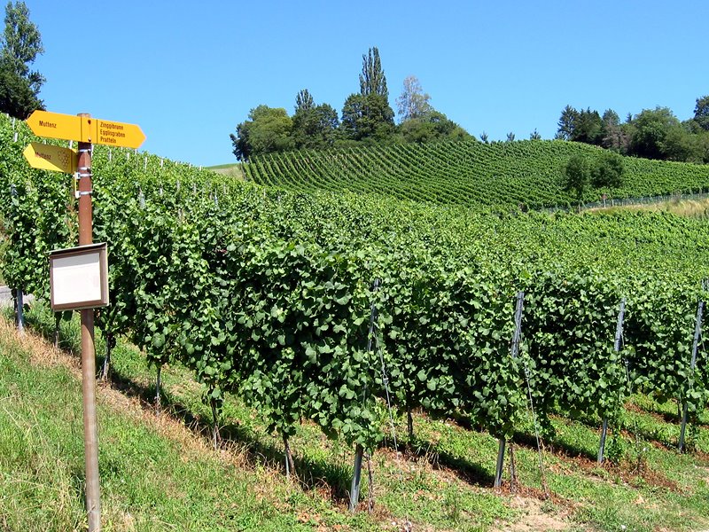
Gempen -> Muttenz
This 10 km hike from Gempen to Muttenz by way of Schönmatt, Sulzchopf, and Egglisgraben was another U-Abo suggestion.
This was more rural than the two previous hikes we've done (a pleasant change) and included a couple of very good panoramic viewing points and a nice break with a refreshing drink at Egglisgraben. The final stretch through the vineyards of Muttenz was a bit hot, but otherwise really nice.

This was more rural than the two previous hikes we've done (a pleasant change) and included a couple of very good panoramic viewing points and a nice break with a refreshing drink at Egglisgraben. The final stretch through the vineyards of Muttenz was a bit hot, but otherwise really nice.
Sunday, July 09, 2006
Birsfelden -> Rheinfelden
Another hike from Wandern mit dem U-Abo, this one runs along the Rhine, through woods, between big harbor facilities, past Roman ruins, and through some little towns. It is a nice mix of scenery and is a very flat 13km.
No pictures from this hike.
No pictures from this hike.
Sunday, July 02, 2006
Riehen -> Burg Rotteln
This is a hike from Wandern mit dem U-Abo, so we could take the tram. The 15km hike into Germany is pretty flat and gives great views of the surrounding area (particularly the lower Schwarzwald).
We had a bit of bad timing: July 2 was a big event day at the Burg Rotteln, so the place was crawling with groups of singers; but at least everything was free and we did have a lot of fun exploring the Burg. :-)

We had a bit of bad timing: July 2 was a big event day at the Burg Rotteln, so the place was crawling with groups of singers; but at least everything was free and we did have a lot of fun exploring the Burg. :-)

Sunday, May 21, 2006
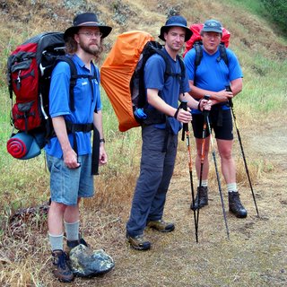
Henry Coe: May 18-21, 2006
Four days backpacking in Henry Coe SP with Chris and Andreas
Day 1: Headquarters (~2600 ft) to Mississippi Lake (~2200 ft), ~11 miles, lots of ups and downs
Corral Trail, Spring Trail, Manzanita Point Rd., Madrone Soda Springs Trail, Mile Trail to China Hole (~1200 ft); The Narrows to Los Cruzeros (~1200 ft); Willow Ridge Trail to Willow Ridge Rd. (~2600 ft), along Rollercoaster Ridge to Mississippi Lake (2200 ft); camp near dam on south side.
On the neverending Rollercoaster Ridge:

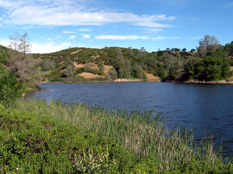
Day 2: rest, stroll around Mississippi Lake, change of camp sites to northern end with picnic table, walk up to County Line Road.
Mississippi Lake:

Day 3: Mississippi Lake (~2200 ft) to Arnold Horse Camp (~1300 ft), ~7 miles
Bear Springs Rd., Bear Mountain Rd. (~2500 ft) to East Fork Coyote Creek (~1400 ft), allong East Fork Coyote Creek to Arnold Horse Camp (~1300 ft).
Not surprisingly, more ups and downs in Henry Coe:

Day 4: Arnold Horse Camp (~1300 ft) to Headquarters (~2600 ft), ~7.5 miles
The Narrows (~1200 ft), Schafer Corral Trail, Poverty Flat Rd. (~1800 ft) to Poverty Flat (~1200 ft); up on Poverty Flat Rd. to Manzanita Point Rd. (~2300 ft), Forest Trail, Corral Trail to Headquarters (~2600 ft).
The rain'll keep us cool:
Day 1: Headquarters (~2600 ft) to Mississippi Lake (~2200 ft), ~11 miles, lots of ups and downs
Corral Trail, Spring Trail, Manzanita Point Rd., Madrone Soda Springs Trail, Mile Trail to China Hole (~1200 ft); The Narrows to Los Cruzeros (~1200 ft); Willow Ridge Trail to Willow Ridge Rd. (~2600 ft), along Rollercoaster Ridge to Mississippi Lake (2200 ft); camp near dam on south side.
On the neverending Rollercoaster Ridge:

Day 2: rest, stroll around Mississippi Lake, change of camp sites to northern end with picnic table, walk up to County Line Road.
Mississippi Lake:
Day 3: Mississippi Lake (~2200 ft) to Arnold Horse Camp (~1300 ft), ~7 miles
Bear Springs Rd., Bear Mountain Rd. (~2500 ft) to East Fork Coyote Creek (~1400 ft), allong East Fork Coyote Creek to Arnold Horse Camp (~1300 ft).
Not surprisingly, more ups and downs in Henry Coe:

Day 4: Arnold Horse Camp (~1300 ft) to Headquarters (~2600 ft), ~7.5 miles
The Narrows (~1200 ft), Schafer Corral Trail, Poverty Flat Rd. (~1800 ft) to Poverty Flat (~1200 ft); up on Poverty Flat Rd. to Manzanita Point Rd. (~2300 ft), Forest Trail, Corral Trail to Headquarters (~2600 ft).
The rain'll keep us cool:

Monday, May 08, 2006
Antler Point: May 7, 2006
SF Bay Area, Joseph D. Grant County Park Santa Clara, 9.2 miles, ~14oo feet verical
Starting from the parking lot near Grant Lake we followed Halls Valley Trail -> Canada de Pala Trail -> Antler Point (2995 feet) -> Pala Seca Trail -> Los Huecos Trail.
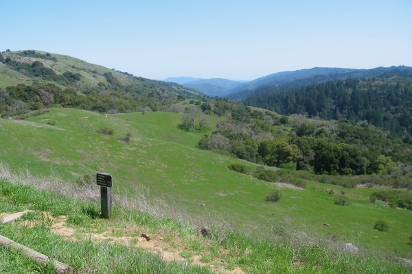
The Bay Area is so *green* in spring:

Starting from the parking lot near Grant Lake we followed Halls Valley Trail -> Canada de Pala Trail -> Antler Point (2995 feet) -> Pala Seca Trail -> Los Huecos Trail.
The Bay Area is so *green* in spring:

Sunday, April 30, 2006
Monte Bello OSP: 30 April, 2006
SF Bay Area Coastal Range, 6.2 miles, ~1000 feet vertical
Starting from the main parking area we followed White Oak Trail -> Canyon Trail -> Indian Creek Trail -> Black Mountain -> Old Ranch Trail -> Bella Vista Trail -> Canyon Trail.
View of Stanford and Palo Alto from the knob above Bella Vista Trail:

Looking down the San Andreas fault from the Bella Vista Trail:

For some reason, this lizard was willing to sit still long enough for me to get a picture... hell, he even posed for it:

Starting from the main parking area we followed White Oak Trail -> Canyon Trail -> Indian Creek Trail -> Black Mountain -> Old Ranch Trail -> Bella Vista Trail -> Canyon Trail.
View of Stanford and Palo Alto from the knob above Bella Vista Trail:

Looking down the San Andreas fault from the Bella Vista Trail:
For some reason, this lizard was willing to sit still long enough for me to get a picture... hell, he even posed for it:

Subscribe to:
Posts (Atom)
